 EMODnet Product Catalogue
OSPAR Commission
Type of resources
Available actions
Topics
Keywords
Contact for the resource
Provided by
Years
Formats
Representation types
Scale 1:
-
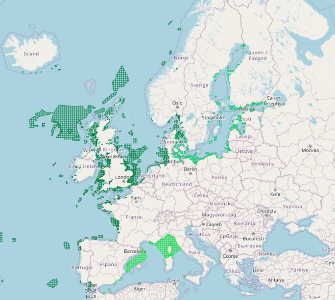
The dataset on Marine Protected Areas (MPAs) established under the framework of the Regional Sea Conventions (RSCs) was created in 2023 by Cogea for the European Marine Observation and Data Network (EMODnet). It is based on spatial data provided by HELCOM (HELCOM_MPAs_2019_2), by SPA/RAC and MedPAN through the MAPAMED database (MAPAMED_SPAMI_2019_edition_version_2), and by OSPAR (OSPAR_MPAs_202107_001). It is available for viewing and download on EMODnet web portal (Human Activities, https://emodnet.ec.europa.eu/en/human-activities). The dataset displays all the MPAs as officially reported by the respective Contracting Parties to the Helsinky Convention, to the Barcelona Convention and to the Convention for the Protection of the Marine Environment of the North-East Atlantic. The RSCs MPAs are established in order to promote the cooperation in the management and conservation of natural areas, as well as in the protection of threatened species and their habitats. Each RSC MPA may be established in the marine and coastal zones subject to the sovereignty or jurisdiction of the Parties and in areas situated partly or wholly on the high sea. Thus, the dataset covers the MPAs Beyond National Jurisdiction (ABNJ) and the MPAs in following countries: Albania, Algeria, Belgium, Cyprus, Denmark, Estonia, Finland, France, Germany, Iceland, Ireland, Italy, Latvia, Lebanon, Lithuania, Monaco, Morocco, the Netherlands, Norway, Poland, Portugal, Russia, Slovenia, Spain, Sweden, Tunisia, and the United Kingdom. Where available each polygon has the following attributes: code, name (english and/or original), designation, country, status (adopted/designated, managed or partly managed, proposed), establishement year, area sqkm (reported, calculated), marine area sqkm (reported, calculated) management authorithy, site link. For further information please visit the data providers websites. This dataset covers the last updated versions in the 2021 and 2022.
-
This dataset includes the data used in in the HELCOM/OSPAR Ballast Water Exemptions Decision Support Tool. This tool was developed in 2013 based on the overall IMO framework, the 21 Baltic and North-East Atlantic coastal states and the EU. It allows user to define “low risk” routes, as well as other necessary steps in granting exemptions under regulation A-4 of the IMO Ballast Water Management Convention (BWMC). The data were collected in various European ports and includes not only biodiversity data but also hydrographic, sediment and meteorological measurements in the sampling sites.
-
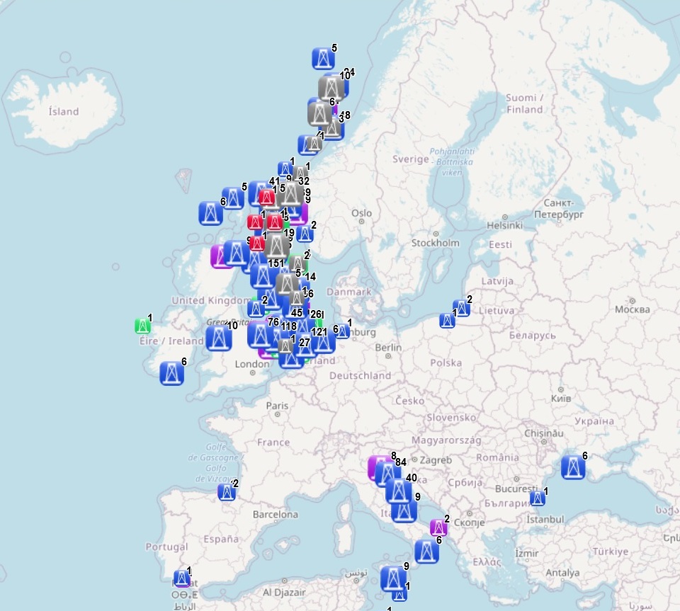
The dataset on offshore installations for Oil and Gas exploitation and exploration activities in the European seas was created in 2015 by Cogea for the European Marine Observation and Data Network (EMODnet). It is the result of the aggregation and harmonization of datasets provided by several EU and non-EU sources. It is updated every year and it is available for viewing and download on EMODnet web portal (Human Activities, https://emodnet.ec.europa.eu/en/human-activities). The dataset contains points representing offshore installations and where available each point has the following attributes: ID, name, country, location block, operator, production start year, primary production, current status, category and function of the installation, sub-structure and topside weights (tonnes), water depth (metres), distance to coast (metres) and notes. The OSPAR commission source covers data for Germany, Ireland, Spain (Atlantic Sea), while for Italy data have been collected and harmonized from the Italian Ministry of Economic Development, for Denmark from the Danish Energy Agency, for the Netherlands from the TNO - Geological Survey of the Netherlands, for Croatia from the Croatian Hydrocarbon Agency, for Norway from the Norwegian Petroleum Directorate, for the UK from the Oil and Gas Authority (surface infrastructures), for Polish and Russian installations in the Baltic Sea from Marine Traffic and Helcom, finally from Marine Traffic come the data for Bulgarian, Russian and Ukrainian installations in the Black Sea and for Spanish installations in the Mediterranean Sea.